AQUIFER

MAYAN PARADISE | ©Mattia Cannatá. Banco de imágenes, CONABIO

NATURAL AND CULTURAL RICHNESS


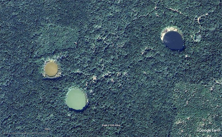
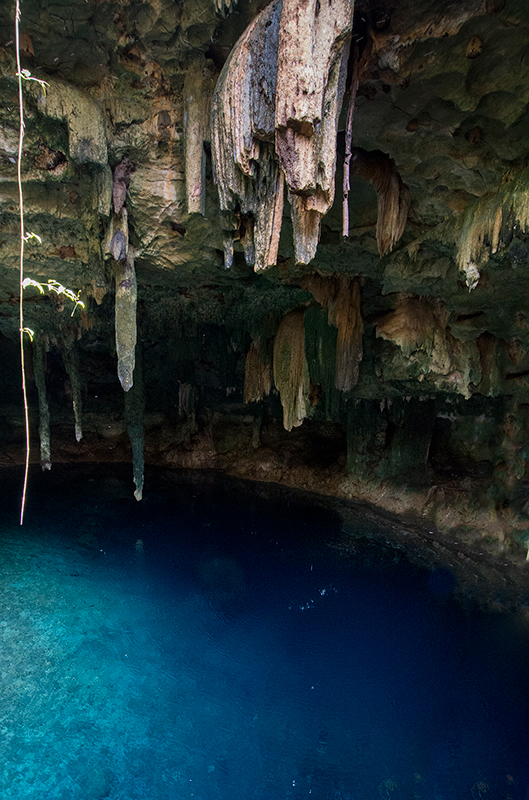
The Yucatan aquifer is one of the largest in the world. It extends for over 2,000 km2 in the states of Campeche, Yucatan and Quintana Roo and it includes the most extensive system of subterranean rivers. Many ecosystems depend on the aquifer from cenotes to magroves and coastal petenes, fed by subterranean water that travels great distances.

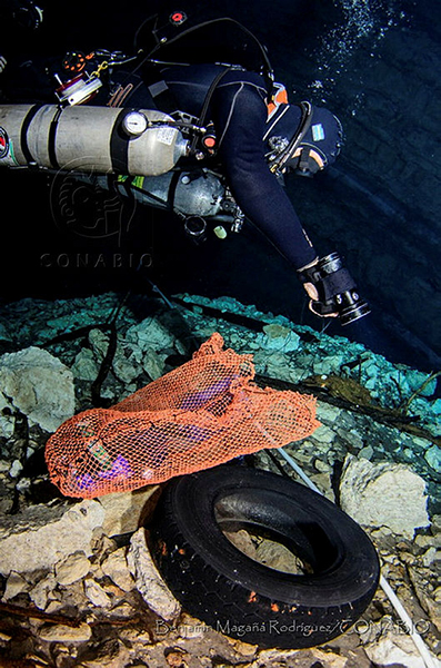
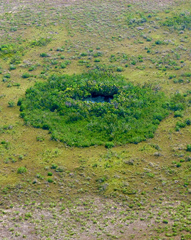
The more than 9,000 cenotes of the peninsula, are home to an incredible diversity of unique species of fishes, crustaceans, and other groups. The aquifer has been the support of the sociocultural ecosystems that developed in the peninsula since over 10,000 years, including the great mayan culture. The health, culture and economy of present and future inhabitants depend on the health of the aquifer.

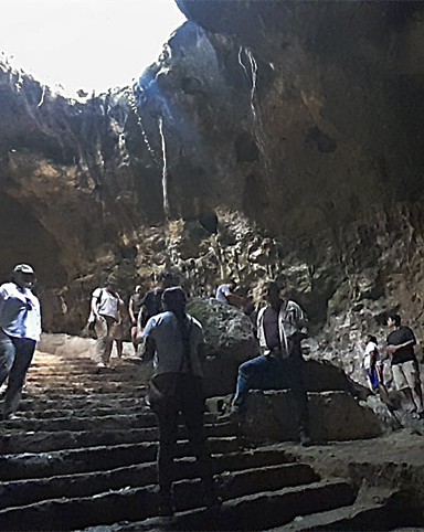
In the Yucatan peninsula the Mayan aquifer represents the source of life, economic activity and the last frontier of exploration in the world, after the oceans. It is a fundamental link between the Gulf of Mexico and the Caribbean basins. The largest underwater cave system of the world, the Sac Actún (White cave), with over 347 kilometers with Ice Age vestiges, from the first settlers of America and the Maya culture. The spectacular "cenotes" are windows to the Earth´s interior where unique species inhabit.


Sistema de cuevas
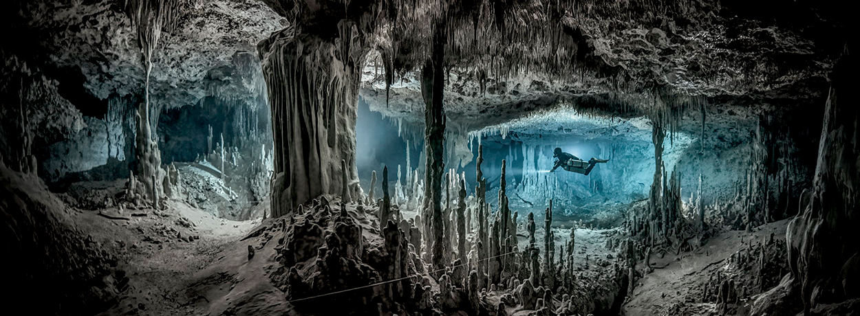
SISTEMA DE CUEVAS | ©Martin Broen

Cenote
CENOTE | ©Iván Montes de Oca Cacheux

SCENARIOS


The main water problems in the Yucatan peninsula are due to deterioration of water quantity and quality in basins and aquifers (CCPY y CONAGUA 2021), particularly in the planning units Norte de Yucatan (Merida) and Norte de Quintana Roo (Cancun). The population, agriculture, animal farms, and tourism are rapidly growing in both regions, with a consequent impact.

The main cities and recent real estate developments transform water catchment areas and discharge their wastewater into the aquifer; agricultural areas pollute with fertilizers and pesticides; pig farms discharge wastewater that carries organic waste (nitrogen and phosphorus), and emerging contaminants, such as antibiotics, which can affect ecosystems dependent on the aquifer. The growing cenote tourism industry also contaminates with microorganisms (bacteria, viruses and protozoa) and with substances included in repellents and sunblockers (Crespo 2022).

A recent review reveals that in a total of 170 cenotes analyzed, in 92% (160) had contaminants of different origins: residual waters and runoffs, infiltration of agricultural and urban activities (Moreno-Pérez et al., 2021).

Limpieza de cenote
CENOTE CLEANING
©Benjamín Magaña Rodríguez. Banco de imágenes, CONABIO.

INICIATIVES


MAYA AQUIFER ALLIANCE

Pollution sources in the Peninsula have diverse origins: residual water from urban zones, fertilizers and insecticides from agricultural, cattle, chicken and pig farms, and cenote tourism. It is critical to critical reverse water pollution to maintain the health of nature and society.

To contribute to the maintenance and restoration of the aquifer´s health Claudia y Roberto Hernández Foundation collaborates in the Maya Aquifer Alliance. This recent initiative gathers a set of foundations (Fundación Gonzalo Río Arronte, National Geographic, The Harte Charitable Foundation, Kellogg Foundation, Ocean Foundation, The Summit Foundation and Fundación Claudia y Roberto Hernández) that are concerned about the water issues in the Peninsula.

The objective of this Alliance is to generate scientific knowledge on the aquifer´s dynamics to implement solutions, along with monitoring to take the pulse of water quality. In turn, the Alliance promotes community participation and capacity building in monitoring activities and communication on the state of the aquifer, problems and solutions.

At present, with the collaboration of several institutions, we have a number of projects working to monitor water quality in Yucatan and Quintana Roo.


Proyecto Ts'onot
©Proyecto Ts´onot

PROJECT TS´ONOT

The objective of Project Ts´onot is to develop a community monitoring network of water quality in Yucatan´s cenotes to restore the aquifer health.

  • Community monitoring network. To promote the participation of society through capacity building of community monitors.
  • Water quality assessments. To conduct lab analysis of water quality to complement community monitoring.
  • Open data platform development. To develop an information portal to share knowledge on the state of water quality in five municipalities to improve water management.
  • Social communication. To develop a communication strategy to promote water quality issues and encourage community participation.

The project is conducted by KALANBIO, A.C. with support from Claudia and Roberto Foundation, Rio Arronte Foundation and Harte Research Institute for Gulf of Mexico Studies, and with collaboration with TAE Foundation, Catherwood Travels, Private Haciendas, Cenoteando, Química, UMDI SISAL and Biodiversidad en Cenotes.


Cenote
CENOTE | ©Claudia Madrazo

PROJECT ZAZIL-JA

The objectives of the Project Zazil-Ja are:

  • To improve our understanding of the Yucatan Peninsula Aquifer through - diagnosis and baseline construction of the present state of the aquifer with relevant stakeholders;
  • To expand monitoring (in collaboration with Project Ts´onot), seeking a long lasting monitoring capacity in collaboration with the National Water Commission, using locally-developed water levels, temperature and salinity sensors, and determining concentrations of natural constituents of groundwater (ions) and various pollutants (bacteria, nutrients, metals, organic persistent and emerging pollutants and tracers) in the critically-stressed northwest region; and
  • to produce regional numerical flow simulations with present and future scenarios of recharge, extraction and sea level.
  • Social communication. To develop a communication strategy to promote water quality issues and encourage community participation.

The project is conducted by Engineering Institute, UNAM-Sisal, Yucatan with support from National Geographic Society and collaboration with Project Tso´not.

DISCOVER MORE

  • CCPY y CONAGUA. 2021. Programa Hídrico Regional 2020-2024. Región Hidrológico Administrativa XII Península de Yucatán. SEMARNAT. México.
  • Crespo, C. 2022. Que impacto tienen los protectores solares?. National Geographic.
  • Medina Carrillo, L.G., J. Fernández Mendiburu y J.O. Montiel Cortés. 2021. Contaminación del acuífero maya, responsabilidad gubernamental y empresarial. Fundación para el Debido Proceso. Indignación, promoción y defensa de los derechos humanos.
  • Moreno-Perez, P.A., M. Hernández y A. Bautista-Gálvez. 2021. In Danger One of the largest aquifers in the world, the Great Mayan Aquifer, based on monitoring the cenotes of the Yucatan Peninsula. Archives of Environmental Contamination and Toxicology. 81:189-198

WEBSITES

CENOTEANDO. Cenote research organization in Yucatan